ST_ClusterDBSCAN
Name
ST_ClusterDBSCAN — Windowing function that returns integer id for the cluster each input geometry is in based on 2D implementation of Density-based spatial clustering of applications with noise (DBSCAN) algorithm.
Synopsis
     integer

      ST_ClusterDBSCAN

     (
geometry winset
geom
, float8
eps
, integer
minpoints
)
;
Description
Returns cluster number for each input geometry, based on a 2D implementation of the
Density-based spatial clustering of applications with noise (DBSCAN)
algorithm. Unlike
ST_ClusterKMeans
, it does not require the number of clusters to be specified, but instead
uses the desired distance (
eps
) and density(
minpoints
) parameters to construct each cluster.
An input geometry will be added to a cluster if it is either:
-
A "core" geometry, that is within
epsdistance (Cartesian) of at leastminpointsinput geometries (including itself) or -
A "border" geometry, that is within
epsdistance of a core geometry.
Note that border geometries may be within
eps
distance of core geometries in more than one cluster; in this
case, either assignment would be correct, and the border geometry will be arbitrarily asssigned to one of the available clusters.
In these cases, it is possible for a correct cluster to be generated with fewer than
minpoints
geometries.
When assignment of a border geometry is ambiguous, repeated calls to ST_ClusterDBSCAN will produce identical results if an ORDER BY
clause is included in the window definition, but cluster assignments may differ from other implementations of the same algorithm.
![[Note]](images/note.png)
|
|
|
Input geometries that do not meet the criteria to join any other cluster will be assigned a cluster number of NULL. |
Availability: 2.3.0 - requires GEOS
Examples
Assigning a cluster number to each polygon within 50 meters of each other. Require at least 2 polygons per cluster
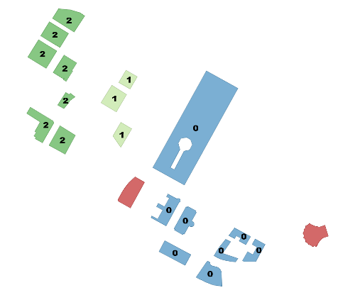
within 50 meters at least 2 per cluster. singletons have NULL for cid
SELECT name, ST_ClusterDBSCAN(geom, eps := 50, minpoints := 2) over () AS cid
FROM boston_polys
WHERE name > '' AND building > ''
	AND ST_DWithin(geom,
        ST_Transform(
            ST_GeomFromText('POINT(-71.04054 42.35141)', 4326), 26986),
           500);
|
name | bucket -------------------------------------+-------- Manulife Tower | 0 Park Lane Seaport I | 0 Park Lane Seaport II | 0 Renaissance Boston Waterfront Hotel | 0 Seaport Boston Hotel | 0 Seaport Hotel & World Trade Center | 0 Waterside Place | 0 World Trade Center East | 0 100 Northern Avenue | 1 100 Pier 4 | 1 The Institute of Contemporary Art | 1 101 Seaport | 2 District Hall | 2 One Marina Park Drive | 2 Twenty Two Liberty | 2 Vertex | 2 Vertex | 2 Watermark Seaport | 2 Blue Hills Bank Pavilion | NULL World Trade Center West | NULL (20 rows) |
Combining parcels with the same cluster number into a single geometry. This uses named argument calling
SELECT cid, ST_Collect(geom) AS cluster_geom, array_agg(parcel_id) AS ids_in_cluster FROM (
    SELECT parcel_id, ST_ClusterDBSCAN(geom, eps := 0.5, minpoints := 5) over () AS cid, geom
    FROM parcels) sq
GROUP BY cid;