ST_ClusterKMeans
Name
ST_ClusterKMeans — Window function that returns a cluster id for each input geometry using the K-means algorithm.
Synopsis
     integer

      ST_ClusterKMeans

     (
geometry winset
geom
, integer
number_of_clusters
, float
max_radius
)
;
Description
Returns K-means cluster number for each input geometry. The distance used for clustering is the distance between the centroids for 2D geometries, and distance between bounding box centers for 3D geometries. For POINT inputs, M coordinate will be treated as weight of input and has to be larger than 0.
max_radius
, if set, will cause ST_ClusterKMeans to generate more clusters than
k
ensuring that no cluster in output has radius larger than
max_radius
.
This is useful in reachability analysis.
Enhanced: 3.2.0 Support for
max_radius
Enhanced: 3.1.0 Support for 3D geometries and weights
Availability: 2.3.0
Examples
Generate dummy set of parcels for examples
CREATE TABLE parcels AS
SELECT lpad((row_number() over())::text,3,'0') As parcel_id, geom,
('{residential, commercial}'::text[])[1 + mod(row_number()OVER(),2)] As type
FROM
    ST_Subdivide(ST_Buffer('SRID=3857;LINESTRING(40 100, 98 100, 100 150, 60 90)'::geometry,
    40, 'endcap=square'),12) As geom;

Original Parcels
|

Parcels color-coded by cluster number (cid)
SELECT ST_ClusterKMeans(geom, 5) OVER() AS cid, parcel_id, geom
FROM parcels;
 cid | parcel_id |   geom
-----+-----------+---------------
   0 | 001       | 0103000000...
   0 | 002       | 0103000000...
   1 | 003       | 0103000000...
   0 | 004       | 0103000000...
   1 | 005       | 0103000000...
   2 | 006       | 0103000000...
   2 | 007       | 0103000000...
(7 rows)
|
Partitioning parcel clusters by type:
SELECT ST_ClusterKMeans(geom, 3) over (PARTITION BY type) AS cid, parcel_id, type
FROM parcels;
 cid | parcel_id |    type
-----+-----------+-------------
   1 | 005       | commercial
   1 | 003       | commercial
   2 | 007       | commercial
   0 | 001       | commercial
   1 | 004       | residential
   0 | 002       | residential
   2 | 006       | residential
(7 rows)
Clustering preaggregated planetary scale data like population dataset may require using 3D clusering and weighting. Let's try to idenify 20-ish meta-regions based on Kontur Population that will not span more than 3000 km from their center:
create table kontur_population_3000km_clusters as
select
    geom,
    ST_ClusterKMeans(
        ST_Force4D(
            ST_Transform(ST_Force3D(geom), 4978), -- cluster in 3D XYZ CRS
            mvalue := population -- set clustering to be weighed by population
        ),
        20,                      -- aim to generate at least 20 clusters
        max_radius := 3000000    -- but generate more to make each under 3000 km radius
    ) over () as cid
from
    kontur_population;
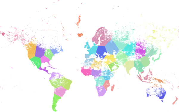
World population clustered to above specs: 46 resulting clusters. Greenland is one cluster, there are island clusters that span across antimeridian, clusters are centered at well-populated regions (New York, Moscow), and edges follow Earth's curvature.
See Also
ST_ClusterDBSCAN , ST_ClusterIntersecting , ST_ClusterWithin , ST_Subdivide , ST_Force3D , ST_Force4D ,