ST_Transform
Name
ST_Transform — Reprojects a raster in a known spatial reference system to another known spatial reference system using specified resampling algorithm. Options are NearestNeighbor, Bilinear, Cubic, CubicSpline, Lanczos defaulting to NearestNeighbor.
Synopsis
     raster

      ST_Transform

     (
raster
rast
, integer
srid
, text
algorithm=NearestNeighbor
, double precision
maxerr=0.125
, double precision
scalex
, double precision
scaley
)
;
     raster

      ST_Transform

     (
raster
rast
, integer
srid
, double precision
scalex
, double precision
scaley
, text
algorithm=NearestNeighbor
, double precision
maxerr=0.125
)
;
     raster

      ST_Transform

     (
raster
rast
, raster
alignto
, text
algorithm=NearestNeighbor
, double precision
maxerr=0.125
)
;
Description
Reprojects a raster in a known spatial reference system to another known spatial reference system using specified pixel warping algorithm. Uses 'NearestNeighbor' if no algorithm is specified and maxerror percent of 0.125 if no maxerr is specified.
Algorithm options are: 'NearestNeighbor', 'Bilinear', 'Cubic', 'CubicSpline', and 'Lanczos'. Refer to: GDAL Warp resampling methods for more details.
ST_Transform is often confused with ST_SetSRID(). ST_Transform actually changes the coordinates of a raster (and resamples the pixel values) from one spatial reference system to another, while ST_SetSRID() simply changes the SRID identifier of the raster.
Unlike the other variants, Variant 3 requires a reference raster as
alignto
. The transformed raster will be transformed to the spatial reference system (SRID) of the reference raster and be aligned (ST_SameAlignment = TRUE) to the reference raster.
![[Note]](./images/note.png)
|
|
|
If you find your transformation support is not working right, you may need to set the environment variable PROJSO to the .so or .dll projection library your PostGIS is using. This just needs to have the name of the file. So for example on windows, you would in Control Panel -> System -> Environment Variables add a system variable called
|
![[Warning]](./images/warning.png)
|
|
|
When transforming a coverage of tiles, you almost always want to use a reference raster to insure same alignment and no gaps in your tiles as demonstrated in example: Variant 3. |
Availability: 2.0.0 Requires GDAL 1.6.1+
Enhanced: 2.1.0 Addition of ST_Transform(rast, alignto) variant
Examples
SELECT ST_Width(mass_stm) As w_before, ST_Width(wgs_84) As w_after,
  ST_Height(mass_stm) As h_before, ST_Height(wgs_84) As h_after
    FROM
    ( SELECT rast As mass_stm, ST_Transform(rast,4326) As wgs_84
  ,  ST_Transform(rast,4326, 'Bilinear') AS wgs_84_bilin
        FROM aerials.o_2_boston
            WHERE ST_Intersects(rast,
                ST_Transform(ST_MakeEnvelope(-71.128, 42.2392,-71.1277, 42.2397, 4326),26986) )
        LIMIT 1) As foo;

 w_before | w_after | h_before | h_after
----------+---------+----------+---------
      200 |     228 |      200 |     170
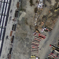
original mass state plane meters (mass_stm) |
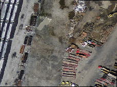
After transform to wgs 84 long lat (wgs_84) |
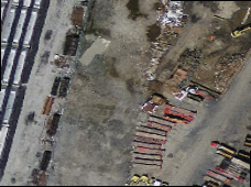
After transform to wgs 84 long lat with bilinear algorithm instead of NN default (wgs_84_bilin) |
Examples: Variant 3
The following shows the difference between using ST_Transform(raster, srid) and ST_Transform(raster, alignto)
WITH foo AS (
    SELECT 0 AS rid, ST_AddBand(ST_MakeEmptyRaster(2, 2, -500000, 600000, 100, -100, 0, 0, 2163), 1, '16BUI', 1, 0) AS rast UNION ALL
    SELECT 1, ST_AddBand(ST_MakeEmptyRaster(2, 2, -499800, 600000, 100, -100, 0, 0, 2163), 1, '16BUI', 2, 0) AS rast UNION ALL
    SELECT 2, ST_AddBand(ST_MakeEmptyRaster(2, 2, -499600, 600000, 100, -100, 0, 0, 2163), 1, '16BUI', 3, 0) AS rast UNION ALL

    SELECT 3, ST_AddBand(ST_MakeEmptyRaster(2, 2, -500000, 599800, 100, -100, 0, 0, 2163), 1, '16BUI', 10, 0) AS rast UNION ALL
    SELECT 4, ST_AddBand(ST_MakeEmptyRaster(2, 2, -499800, 599800, 100, -100, 0, 0, 2163), 1, '16BUI', 20, 0) AS rast UNION ALL
    SELECT 5, ST_AddBand(ST_MakeEmptyRaster(2, 2, -499600, 599800, 100, -100, 0, 0, 2163), 1, '16BUI', 30, 0) AS rast UNION ALL

    SELECT 6, ST_AddBand(ST_MakeEmptyRaster(2, 2, -500000, 599600, 100, -100, 0, 0, 2163), 1, '16BUI', 100, 0) AS rast UNION ALL
    SELECT 7, ST_AddBand(ST_MakeEmptyRaster(2, 2, -499800, 599600, 100, -100, 0, 0, 2163), 1, '16BUI', 200, 0) AS rast UNION ALL
    SELECT 8, ST_AddBand(ST_MakeEmptyRaster(2, 2, -499600, 599600, 100, -100, 0, 0, 2163), 1, '16BUI', 300, 0) AS rast
), bar AS (
    SELECT
        ST_Transform(rast, 4269) AS alignto
    FROM foo
    LIMIT 1
), baz AS (
    SELECT
        rid,
        rast,
        ST_Transform(rast, 4269) AS not_aligned,
        ST_Transform(rast, alignto) AS aligned
    FROM foo
    CROSS JOIN bar
)
SELECT
    ST_SameAlignment(rast) AS rast,
    ST_SameAlignment(not_aligned) AS not_aligned,
    ST_SameAlignment(aligned) AS aligned
FROM baz

 rast | not_aligned | aligned
------+-------------+---------
 t    | f           | t

not_aligned
|

aligned
|