About Tiles
The tiles produced by PostGIS and published via pg_tileserv are “Mapbox vector tiles”, a widely used de facto standard encoding of vector tiles.
The purpose of vector tiles is to efficiently transfer map features over the network, so they optimize for size, using a variety of techniques while retaining enough context to be useful to the client mapping environment.
Resolution
Coordinates in tiles are quantized to integer values, and the default resolution of vector tiles is 4096 by 4096. The default resolution can be altered using the DefaultResolution configuration parameter.
Tile Buffer
Tiles are rendered independently. For features with wide styles near borders, a copy of the feature needs to appear in both neighboring tiles, or a rendering failure will occur.
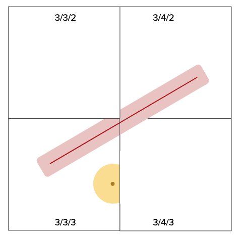
The default tile buffer is 256 pixels, which is enough for most rendering cases. You can make your tiles smaller if you have narrow rendering styles, by reducing the DefaultBuffer configuration parameter.
Unique Identifier
The vector tile specification includes an optional “id” element that provides a unique feature identifier.
A single feature can end up in multiple tiles, and the unique identifier allows the client side renderer to do things like roll-overs and highlights on features that span tile boundaries.
The tile server can automatically populate the “id” element, but only in cases where:
- PostGIS version is >= 3.0, as the ST_AsMVT() function did not support feature id until then.
- The table being published has a integer primary key defined. This key will be used as the “id” automatically.
For function layers, the “id” can be populated, but that task is left to the function author, who will be calling the ST_AsMVT() function in their code, and must remember to populate the feature id name field. The column that is chosen to populate the “id” element must be unique per feature.
Layer Name
The ST_AsMVT() function includes a parameter for the “name”. This is the “layer name” that client rendering engines will use to identify this particular set of features, to apply a style to those features.
For example, in MapLibre, the source-layer attribute for a layer must match the layer name that is in the vector tile source, in order for the rendering rules in that layer to be applied. If you leave the “name” attribute blank in your ST_AsMVT() call, the name will be set to “default”, and so your source-layer must also be set to “default” in order for your tile layer to render.